


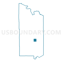
Colvin Twp. Voting District, St. Louis County, Minnesota
About
Outline

Summary
| Unique Area Identifier | 604232 |
| Name | Colvin Twp. Voting District |
| County | St. Louis County |
| State | Minnesota |
| Area (square miles) | 35.94 |
| Land Area (square miles) | 33.70 |
| Water Area (square miles) | 2.24 |
| % of Land Area | 93.77 |
| % of Water Area | 6.23 |
| Latitude of the Internal Point | 47.32386420 |
| Longtitude of the Internal Point | -92.22851370 |
Maps


Graphs
Select a template below for downloading or customizing gragh for Colvin Twp. Voting District, St. Louis County, Minnesota


Neighbors
Neighoring Voting District (by Name) Neighboring Voting District on the Map
- Ellsburg Twp. Voting District, St. Louis County, MN
- Unorg. Prct. 14, St. Louis County, MN
- Unorg. Prct. 17, St. Louis County, MN
- Unorg. Prct. 3, St. Louis County, MN
- Unorg. Prct. 6, St. Louis County, MN
- White Twp. P-2, St. Louis County, MN
Top 10 Neighboring County Subdivision (by Population) Neighboring County Subdivision on the Map
- White township, St. Louis County, MN (3,229)
- Makinen UT, St. Louis County, MN (1,310)
- Whiteface Reservoir UT, St. Louis County, MN (473)
- Colvin township, St. Louis County, MN (317)
- Ellsburg township, St. Louis County, MN (219)
Top 10 Neighboring Unified School District (by Population) Neighboring Unified School District on the Map
- St. Louis County School District, MN (17,844)
- Eveleth-Gilbert School District, MN (8,590)
- Mesabi East School District, MN (7,506)